Python में Geospatial Data के साथ काम करना
Joris Van den Bossche
Open source software developer and teacher, GeoPandas maintainer
GeoDataFrame/GeoSeries का .crs attribute:
import geopandas
gdf = geopandas.read_file("countries.shp")
print(gdf.crs)
{'init': 'epsg:4326'}
gdf_noCRS = geopandas.read_file("countries_noCRS.shp")
print(gdf_noCRS.crs)
{}
crs में CRS जानकारी जोड़ें:
# Option 1
gdf.crs = {'init': 'epsg:4326'}
# Option 2
gdf.crs = {'proj': 'longlat', 'datum': 'WGS84', 'no_defs': True}
import geopandas
gdf = geopandas.read_file("countries_web_mercator.shp")
print(gdf.crs)
{'init': 'epsg:3857', 'no_defs': True}
to_crs() method:
# Option 1 gdf2 = gdf.to_crs({'proj': 'longlat', 'datum': 'WGS84', 'no_defs': True})# Option 2 gdf2 = gdf.to_crs(epsg=4326)
1) अलग CRS वाले sources
df1 = geopandas.read_file(...)
df2 = geopandas.read_file(...)
df2 = df2.to_crs(df1.crs)
1) अलग CRS वाले sources
2) मैपिंग (आकार और दूरी में विकृति)
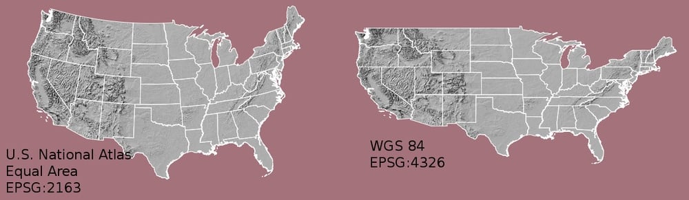
1) अलग CRS वाले sources
2) मैपिंग (आकार और दूरी में विकृति)
3) दूरी/क्षेत्रफल आधारित गणनाएँ
टिप्स:
उपयोगी साइट्स:
to_crs() methodउपयोगी साइट्स:
Python में Geospatial Data के साथ काम करना